Product Description
Details :
- Showing latest boundaries
- Political features
- Capital cities and important towns
- Certified by Survey of India
- Size 70 x 100 cm
- Printed in multicolour on 80 gsm map litho paper
- Laminated with hot seal polyester film on both sides
- Fitted with first quality plastic rollers at top and bottom.
- Available in English.
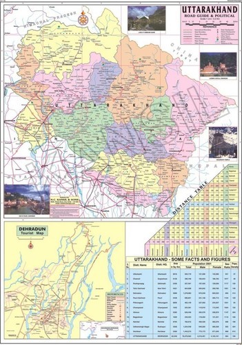
Detailed Political FeaturesThis map showcases Uttarakhands political boundaries with precision, clearly labeling each city and district. The standard cartographic scale aids in accurate understanding of distances and relative locations. Suitable for study, planning, and reference, its clarity and detail serve the needs of learners and professionals alike.
Durable and User-Friendly MaterialPrinted on high-quality, laminated paper, the map is waterproof, easy to clean, and highly durable. Its glossy surface enhances visibility, while the strong lamination protects against wear, making it suitable for frequent handling and long-term display in varied environments.
Effortless Installation and MaintenanceArriving rolled in a protective tube, the map can be mounted instantly using tape or pins without needing any special assembly. Easy to maintain, simply wipe the surface for cleaning. The maps rectangular, portrait format fits most wall spaces, providing an elegant and functional display.
FAQs of Uttarakhand Political Map:
Q: How can I mount the Uttarakhand Political Map on my wall?
A: You can easily mount the map using pins or tape, as its laminated surface and lightweight material allow for secure attachment without special tools.
Q: What is the main use of this map?
A: The map is ideal for educational and reference purposes, displaying political boundaries, marked cities, and districts across Uttarakhand with accuracy.
Q: When should I use this map?
A: Use this map during geography classes, exam preparation, administrative planning, or anytime you need a clear visual of Uttarakhands political divisions.
Q: Where should I ideally place this map for best usage?
A: It is suitable for schools, colleges, libraries, offices, or at homeanywhere you need a large, visible, up-to-date political map of Uttarakhand.
Q: What makes this map durable and easy to maintain?
A: The laminated paper ensures the map is waterproof, easy to wipe clean, and resistant to tearing or creasing, even with regular use.
Q: How accurate are the boundaries and labels on this map?
A: Each boundary and label is created according to standard cartographic practices by a certified educational map publisher, ensuring accuracy and reliability.
Q: What benefits does the glossy laminated finish provide?
A: The glossy finish enhances colour vibrancy, makes labels clear, protects the map from moisture, and allows for easy cleaningideal for high-traffic environments.

 English
 Spanish
 French
 German
 Italian
 Chinese (Simplified)
 Japanese
 Korean
 Arabic
 Portuguese