Product Description
Details: - Designed by experts in a most scientific way.
- Each chart is printed in natural colours.
- Size 70 -100 cms.
- Available in English & Hindi combined.
- Printed in multicolour on 80 gsm map litho paper
- Laminated with hot seal polyester film on both sides
- Fitted with first quality plastic rollers at top and bottom.
- Clearly depicting in diagrams & letters.
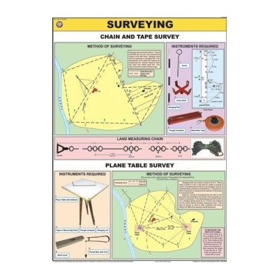
- Chain Tape Survey & Plane Table Survey
- Various instruments required & the technique
High Durability and PracticalityManufactured on synthetic paper with a glossy laminated finish, the SURV-CHT-001 Surveying Chart is engineered to withstand water, tearing, and temperature variations. Its robust construction makes it ideal for frequent use in both indoor educational settings and outdoor field environments.
Comprehensive Educational ToolFeaturing clear diagrams and concise, easy-to-read content, this survey chart serves as a reliable aid for learning and referencing surveying methods. It covers essential instruments and procedures, catering to a broad age range from school students to working professionals.
Flexible Mounting and Usage OptionsDesigned for user convenience, the chart can be wall-mounted for classroom displays or used as a handy desk reference during lessons and fieldwork. Its lightweight A3 format ensures portability without compromising readability or detail.
FAQs of Surveying Chart:
Q: How can the SURV-CHT-001 Surveying Chart be mounted or displayed?
A: This chart is versatile and can be wall-mounted for static classroom use or placed on desks for hands-on reference. No assembly is required for either option.
Q: What materials are used to make the chart durable and resistant to damage?
A: The chart is printed on synthetic paper with a glossy laminated surface, making it resistant to water, tearing, and temperature changes. This ensures a long lifespan, even under demanding conditions.
Q: When is it most beneficial to use this surveying chart?
A: The chart proves valuable both during classroom lessons for visual learning and in the field as a practical reference for surveying exercises or instruction.
Q: Where can this chart be utilized for maximum effectiveness?
A: It is suitable for use in schools, colleges, training institutes, and outdoor educational settings, providing clarity and convenience wherever surveying is taught or practiced.
Q: What is the primary educational advantage of the charts design and content?
A: Its multicolored, high-resolution diagrams and concise explanations make complex surveying concepts accessible, aiding both novice learners and experienced professionals.
Q: How does the chart aid in the learning process for surveying?
A: By presenting detailed information, labeled diagrams, and step-by-step procedures, the chart facilitates quick comprehension and reinforces important surveying principles.

 English
 Spanish
 French
 German
 Italian
 Chinese (Simplified)
 Japanese
 Korean
 Arabic
 Portuguese