Product Description
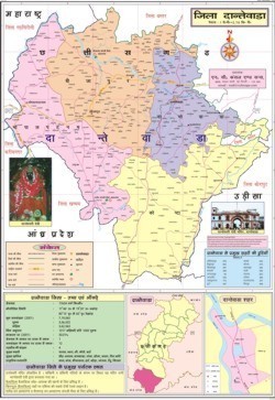
The Dantewada District Map provides a detailed geographical overview of Dantewada, located in the southern part of Chhattisgarh, India. The district is known for its rich cultural heritage, dense forests, mineral resources, and tribal communities. The map highlights important towns, villages, rivers, roads, and administrative boundaries, making it a useful guide for travelers, researchers, and government planning. Dantewada is bordered by Bastar, Bijapur, and Sukma districts, and is famous for landmarks like the Danteshwari Temple, Bailadila hills, and its iron ore mines. A well-structured district map helps in understanding connectivity, tourism routes, resource distribution, and developmental planning within Dantewada.
Dantewada District Map
- Size 70x100
- Laminated Paper
- World Map
FAQs of Dantewada District Map:
Q: What type of map is the Dantewada District Map?
A: The Dantewada District Map is a District Map designed in an informational and educational style.
Q: What is the advantage of using the Dantewada District Map?
A: The Dantewada District Map provides detailed geographical and administrative information about the Dantewada district, making it useful for reference planning and administrative purposes.
Q: What are the typical dimensions of the Dantewada District Map?
A: The approximate estimation of the typical dimensions of the Dantewada District Map is Height: 290px and Width: 200px in a rectangular format.
Q: What features are included in the Dantewada District Map?
A: The Dantewada District Map features detailed administrative divisions, major towns, cultural landmarks, and religious sites, with regions highlighted in distinct colors.
Q: What is the assembly marked on the Dantewada District Map?
A: The Dantewada Assembly constituency is marked on the Dantewada District Map, adding to its educational and informational value.
Q: For what purposes can the Dantewada District Map be used?
A: The Dantewada District Map can be used for educational, administrative, and tourism-related purposes, offering comprehensive information about the district.
Q: What is the model number of the Dantewada District Map?
A: The model number of the Dantewada District Map is Map-Dantewada-2023.

 English
 Spanish
 French
 German
 Italian
 Chinese (Simplified)
 Japanese
 Korean
 Arabic
 Portuguese